Hampsthwaite Village Plan
Implementation Group
Report of the sub-group on "Roads and Transport"

Background
The Village Plan completed in 2007 reported on the results of a questionnaire distributed to all households in the village and which dealt with many issues perceived to be of interest to residents. The section dealing with "Roads and Transport" listed a number of points seeming to require further action by those concerned to give effect to the Plan. This report concentrates on three of those points only (remaining issues will be the subject of a further report in due course) namely the review of . . .
- speed limits and traffic - calming measures
- street lighting
- parking restrictions at key points.
We offer this report and its recommendations for consideration and approval by the full Implementation Group and (if so approved) for its submission to the Hampsthwaite Parish Council so that the Council may decide whether to adopt our recommendations as formal proposals to be advanced by the Council to the Highway Authority.
Bill AtkinsonMaurice Brown
Paul Parker
29.10.2007
| Top |
Introduction
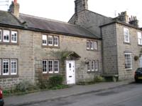
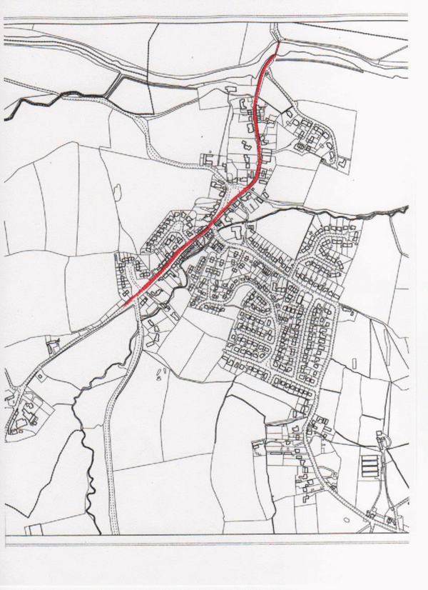
Whether by inspecting the Ordnance Survey maps of the early nineteenth century or observing the appearance of buildings in the village, it seems clear that the principal thoroughfare through the village has, historically, been that which runs North to South. The road which follows that route is named Main Street as it approaches the village green from the south and Church Lane from the green to the river Nidd in the north. The local architecture is clearly divided between between that of the 20th/21st centuries lying mainly to the east of the village centre and the much earlier examples lining the north/south route. There has obviously been a dramatic increase in building during the last decades of the 20th century (the Brookfield area) and the last few years (St. Thomas a'Becket Walk). Modern traffic not only follows the ancient north-south route but also the eastern approach along Hollins Lane and the western route towards Birstwith. There can be no doubt about the increase in level of vehicle traffic in recent years and this is due not only to vehicles passing through the village en route to other locations but also to local traffic including drivers using the local amenities (school, church, shop, post office, garage, public house etc.). At present, all roads (save one) passing through the village are subject to 30mph speed limits. The exception is Church Lane where a 20mph restriction seeks to protect inter alia the users of the village primary school. The Village Plan reports that no less than 59% of respondents to the questionnaire perceived a problem with speeding traffic affecting almost every road in the village. Other complaints included the topics of street lighting and parking.
In the preparation of this report we have made a photographic record of the road scenes as viewed by the drivers of saloon cars. That record with a textual commentary is attached hereto as Appendix A.
Just as the population and housing stock in the village has grown randomly over the years so too, it can be assumed, have the road speed controls, signs , etc., proliferated on an ad hoc basis. Hampsthwaite has suffered in recent years from such an approach e.g. the 20mph speed limit and numerous associated signs around the village green and school; the ineffectual speed hump in Hollins Lane; the ill-defined "raised" platform outside The Joiners public house. We believe that local needs now require a "holistic" approach to traffic control for the village i.e. that the controls should reflect an over-all view of the whole of the built environment and its residents and their needs.
We have considered the guidance contained in Department of Transport Circular 01/2006 entitled "Setting Local Speed Limits" and we believe that the Hampsthwaite situation requires the creation of a single 20mph zone covering almost all of the present 30mph and 20mph restricted roads in the village. We think that a balanced case assessing both the benefits and disadvantages of such a scheme can be presented to the Highway Authority and that any associated improvement measures could then be considered for incorporation into the Local Transport Plan.
Relevant sections of the DoT Circular are annexed hereto as Appendix B. Section 6.3 states "it is Government policy that, where appropriate a 30mph limit should be the norm in villages". Section 6.3 clause 119 also states "it may be appropriate in some larger villages to consider 20mph zones."
Hampsthwaite with its 1000+ population can be considered to be a "larger" village and, indeed, must be thought so by comparison with nearby Pannal and other villages where 20mph zones have already been created.
We consider the objectives of introducing a single 20mph zone to be:-
- The reduction of the risk of accidents and casualties
- Overcoming social exclusion
- Providing sustainable economic and environmental improvement
- Enhancing the quality of life of the local community
| Top |
Road users
Assessing the risks to vulnerable road users is key to an understanding of these objectives and there are a number of specific issues arising in Hampsthwaite to take into account.
Pedestrians crossing roads in the village centre
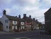
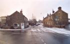
There are a number of community facilities in the village centre - a surgery, shop, post office, public house, hair salon, seat/garden area, telephone kiosk and car showroom. Consequently, pedestrians regularly cross the roads at this location and are affected by vehicular movements. Visibility is restricted where Hollins Lane adjoins High Street/Main Street and this restriction presents a significant hazard. The road surface has been raised as a platform but this does little to address the hazard and neither do the bollards recently inserted into the pavement edge.
Memorial Hall and Bus Shelter
The Memorial Hall and Bus Shelter are sited in Hollins Lane close to the village centre. The shelter is the collection and drop-off point for children attending secondary schools in Harrogate. The Halls car park and the shelter are popular sites for young people to congregate, particularly out of school hours. The Memorial Hall is used for a wide variety of village activities for both young children (e.g. Brownies) and the elderly.
All of this leads to a proliferation of vehicle and pedestrian movements where the forward visibility for drivers is constrained by the road geometry and boundary walls. Again, this presents a hazard.
Football field and childrens play area
Further along Hollins Lane at the junction with Hollins Close is the main access to the football field and play area (off Hollins Close). Parents and children living on Brookfield cross Hollins Lane at this point to gain access to the sports and leisure facility. Only last year there was an accident at this junction when a young child was hit by a car.
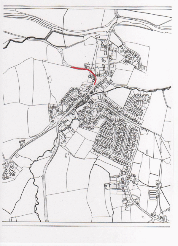
The school and green
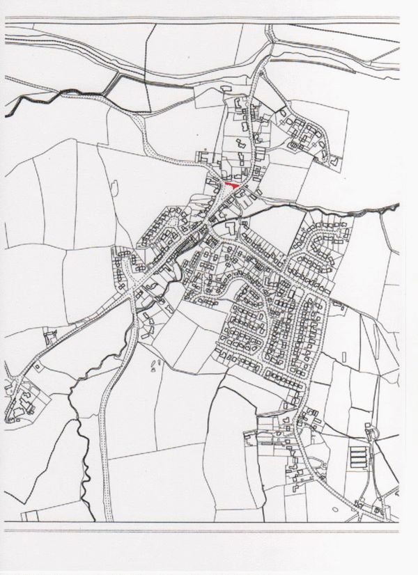
A 20mph speed limit already applies to that side of the Village Green upon which the school abuts and the restriction continues down Church Lane until it nears the river bridge. However, when approaching from the village centre there is no warning of this fact in advance of the point where the restriction begins and the abundance of traffic signs at that point can be confusing for drivers. Furthermore, the school premises are in extremely close proximity to the start of the zone thus diminishing driver awareness of the potential dangers. Whilst the speed restriction is clearly necessary, its extension to encompass the adjacent central area of the village would be sensible.
High Street
The housing on the east side of High Street (one of the three main roads converging on the village centre) comprises terraced cottages with no facilities for off-street parking and, in consequence, residents and visitors park vehicles on this side of the road. Moving traffic in both directions occupies the western half of the carriageway and a hazard is created for pedestrians wishing to cross the High Street from Peckfield and Meadow Closes to the corner shop, Hollins Lane, the Memorial Hall and bus stop.
Cyclists and others
The use of the roads in and around Hampsthwaite by cyclists is noticeable, particularly at weekends and during summer evenings. Horse riders are also frequently encountered (hardly surprising in this rural area!). The Army Foundation College is situated a few miles away and signs in the village already warn motorists of the risk of encountering marching troops.
General Overview
Hampsthwaite enjoys the benefit of a village centre with a range of facilities which are well used by its community and visitors alike. However, this creates considerable movements between pedestrians, cyclists and vehicles with the associated risks. The village accommodates a wide spectrum of age groups and those at either end of the spectrum are particularly vulnerable.
| Top |
Risk Assessment
If the existing 20mph zone were to be extended in the manner we have proposed we anticipate the following benefits/disadvantages would arise . . .
Accident and casualty rates- Benefit
Journey times (vehicles) - Disadvantage
Traffic flow and emissions - No significant change
Journey time reliability (vehicles)- No significant change
Environmental impact - Opportunity for social and visual benefit
Level of public anxiety- Benefit
Level of severance by fast-moving vehicles - Benefit
Conditions and facilities for vulnerable road users - Opportunity for significant benefit
Cost of measures and maintenance - Disadvantage
Cost & visual impact of signage - Benefit
Cost of enforcement - No significant change
| Top |
Suggested engineering measures
Church Lane
- the single carriageway bridge over the river Nidd provides an existing physical constraint and "gateway". No suggested change other than appropriate signage.High Street
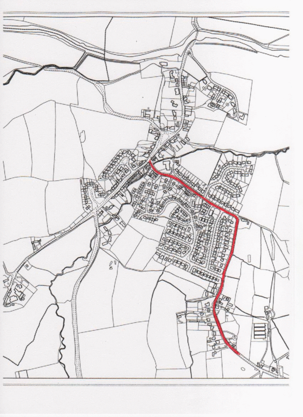
- proposed physical gateway on the village sideof Peckfield Close junction (to avoid visibility splay).Hollins Lane
- proposed physical gateway between Dale Closeand Dawson Court (or does the prospect offuture housing development at Cruet Farm require a gateway further east?).Birstwith Road
- proposed physical gateway Birstwith side of funeral parlourThese gateways would define a broader 20mph zone than currently exists. It is also suggested that transitions of 400 metres minimum length are introduced to precede each gateway (existing 30mph in the case of Hollins Lane and 40mph elsewhere). The proposed physical delineations would use stone materials and incorporate 20mph signage. Another requirement would be the installation of intermediary traffic-calming measures which could be used to enhance the street scene particularly around the village centre.
| Top |
Conclusion
We believe there is sufficient reason and anecdotal evidence for the Highway Authority to consider the introduction of the wider 20mph zone we envisage. The precedent has already been set for a limited part of the village (by the school) and we consider our proposal to be in line with the objectives expressed in the Department of Transport Circular of 2006
| Top |
Street lighting
The Village Plan reports that 21% of those responding to the questionnaire wanted to see more street lighting. We have noted the number and position of street lights in the village and prepared a plan showing their location - the plan is annexed hereto as Appendix C.
It is evident both from the plan and on the ground that there is a sharp distinction in the level of street lighting found in the village Conservation Area and that elsewhere. In the Conservation Area (broadly, High Street and Church Lane) there are very few lights indeed and at night these areas are positively dark with only one lamp-standard (outside the school) and three wall lamps at different points to illuminate the way for pedestrian traffic.There is no doubt that making ones way on foot in these areas at night can be difficult for those not equipped with torches or a good understanding of the route. By contrast, all other areas of the village seem to have a generous number of lamp-standards and their spacing and frequency appear consistent with the urban areas of Harrogate. Obviously, the approach in the past has been to avoid introducing an intrusive number of lights into the Conservation Area. When talking to residents in the Conservation Area it is apparent that there would be strong resistance to any change. The Village Plan recorded some residents as viewing increased lighting as "spoiling the village environment". Having regard to modern attitudes to the problems of light pollution, the purpose of Conservation Areas and the likely wishes of those residents most directly affected we are not minded to recommend any action on this issue at present.
[One step we would like to see taken is the replacement in time of the existing "modern" wall lights in High Street and Church Lane with lamps of a more "period" style in keeping with the local architecture. We suggest the Parish Council could attempt to obtain the Highways Department agreement to contact the Parish Council when contemplating repair/renewal of light fittings so that design considerations are taken into account. It is the Conservation Area which is most at risk in design terms but the Parish Council will, no doubt, wish to be consulted in respect of all street furniture throughout the village]
| Top |
Parking restrictions
The desire to avoid seeing Hampsthwaite lose its "village" character (a strong feature of attitudes encountered in the community) militates against the introduction of yet more parking restriction lines and we are not persuaded of a need to do so save in one respect. In Church Lane outside the school it is often the case that vehicles are parked on the bend leading from the river direction and vehicles approaching from that direction are obliged to move into the off-side lane at the very moment when a driver has little or no view of oncoming traffic. Of course, the presence of parked vehicles acts as a strong incentive to drivers to proceed with caution (and to observe the 20mph speed limit!) but it seems only a matter of time before a head - on collision occurs. The likelihood of this happening seems so real that we recommend consideration be given by the Parish Council to the instigation of a suitable parking restriction.
| Top |
Appendix A
(from the River Nidd to Rowden Lane)
 | Illustrated commentary of driving conditions |
| Top |
Appendix A
(from the Village Green to Birstwith Road)
 | Illustrated commentary of driving conditions |
| Top |
Appendix A
(from Church Lane to the Birstwith Road)
 | Illustrated commentary of driving conditions |
| Top |
Appendix A
(from the village centre towards Hollins Hall)
 | Illustrated commentary of driving conditions |
| Top |
Appendix B
. . . extracts from Department for Transport Circular 01/2006 "Setting Local Speed Limits" :6.2 DUAL CARRIAGEWAY RURAL ROADS
- 110.
- Rural dual carriageways are not covered by the speed assessment framework. Roads with segregated junctions and facilities for vulnerable road users would generally be suitable for 70 mph limits. However, a lower limit may be appropriate if, for example, an accident history indicates that this cannot be achieved safely.
6.3 VILLAGES
- 111.
- Fear of traffic can affect peoples quality of life in villages and it is self-evident that villages should have comparable speed limits to similar roads in urban areas. It is therefore government policy that, where appropriate, a 30 mph speed limit should be the norm in villages.
- 112.
- Traffic Advisory Leaflet 01/04 (DfT, 2004) sets out current policy on achieving lower
speed limits in villages, including a broad definition of what constitutes a village. For the
purpose of applying a village speed limit of 30 mph, a definition of a village can be based
on the following simple criteria relating to frontage development and distance:
- 20 or more houses (on one or both sides of the road); and
- a minimum length of 600 metres.
- 113.
- If there are just fewer than 20 houses, traffic authorities should make extra allowance for any other key buildings, such as a church, shop or school.
- 114.
- The above criteria should give an adequate visual message to drivers to reduce their speed. However, many drivers are unlikely to reduce their speed to the new 30 mph limit if it is over a very short stretch of road, particularly if the end of the limit can be seen at the entry point. It is therefore recommended that the minimum length is at least 600 metres to avoid too many changes in speed limits along a route. Traffic authorities may, however, lower this to 400 metres when the level of development density over this shorter length exceeds the 20 or more houses criterion and, in exceptional circumstances, to 300 metres. Shorter lengths are, however, not recommended.
- 115.
- In some circumstances it might be appropriate to consider an intermediate speed limit of 40 mph prior to the 30 mph terminal speed limit signs at the entrance to a village, in particular where there are outlying houses beyond the village boundary or roads with high approach speeds. For the latter, traffic authorities might also need to consider other speed management measures to support the message of the speed limit and help encourage compliance so that no enforcement difficulties are created for the local police force. Where appropriate, such measures might include a vehicle-activated sign, centre hatching or other measures that would have the effect of narrowing or changing the nature and appearance of the road.
- 116.
- Where the speed limit commences at the village boundary, the village nameplate sign and speed limit roundel may be mounted together using the format prescribed in diagram 2402.1 of TSRGD. The combined sign should be located as near as practicable to the start of the development, so that drivers see housing at the same time as the signs, reinforcing the visual message for reduced speed.
- 117.
- If there are high approach speeds to a village, or the start of the village is not obvious, village gateway treatments can also be an effective way to slow drivers down. Further guidance on the use of gateway and entry treatments is included in Appendix B of this guidance. Advice can also be found in Traffic Advisory Leaflets 13/93 Gateways (DoT, 1993a), 01/94 VISP - A Summary (DoT, 1994a) and 01/04 Village Speed Limits (DfT, 2004).
- 118.
- In situations where the above criteria for a village are not met and there is a lesser degree of development, or where engineering measures are not practicable or costeffective to achieve a 30 mph limit, but a reduction from the national 60 mph speed limit is considered appropriate, traffic authorities should consider alternative lower limits of 40 or 50 mph.
- 119.
- It may also be appropriate in some larger villages to consider 20 mph limits or zones, or Home Zones if lighting and other considerations allow. Such limits should not, however, be considered on roads with a strategic function or on main traffic routes.
| Top |
Appendix C
Street lighting
- - - to follow - - -| Top |